THE STORY OF “NORTH WALES PARK” – TODAY’S PARKSIDE PLACE

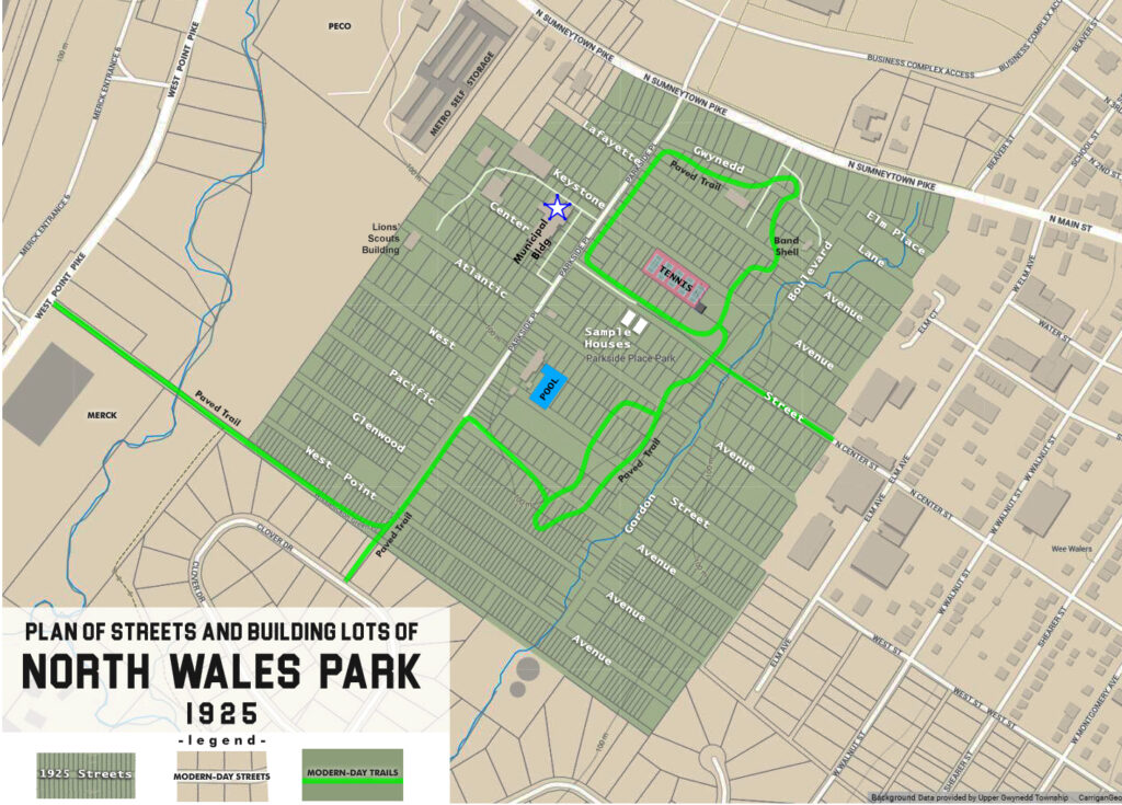
In 1925 Keystone Developing Company purchased and subdivided the 100-acre Gordon tract in Upper Gwynedd Township. The half-mile long southeast boundary line of the property butted up against the borough of North Wales. Keystone Developing Company wasted no time in carving the property into a grid of paper streets and hundreds of building lots to sell to prospective homeowners and investors.  The nearby attractions of the neighboring borough, and the opportunity to commute by way of the electric trolley cars on Sumneytown Pike, were selling features.

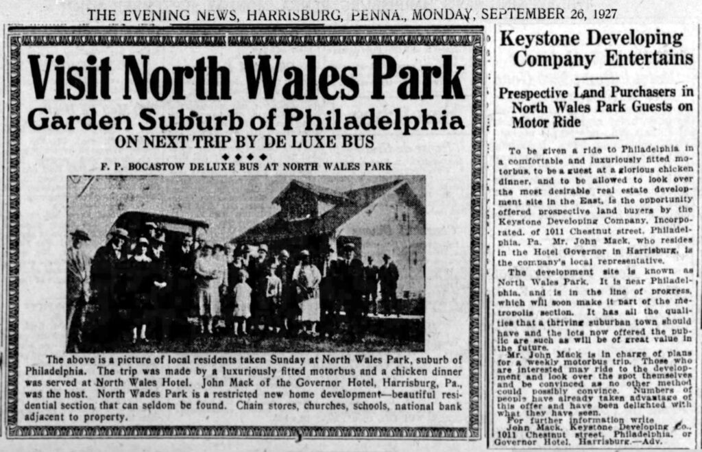
On Sundays in 1926, 1927 and 1928 promoters bussed upstate people to a new development they called North Wales Park, with the promise of a sightseeing outing and complementary chicken dinner.  Only two houses were built, on the southwest side of Center Street.  One is pictured below.  A water main was extended beneath Center Street from North Wales to serve the development.  Neither house survives today. 

Prospective lot buyers were bussed from upstate towns to the North Wales Park development. This photo is posed in front of the sample home on Center Street


At first, the developers offered reasonably sized building lots, but subsequent phases sliced blocks into narrow lots that were too small to construct a suburban house. Deeds to some lots were given away as “prizes.”  Old-timers remember these being referred to as carnival lots or movie lots, because those were among the venues where titles to those properties could be “won.” In subsequent years many lots were subject to sheriff’s sale for nonpayment of property tax (amounts owed seldom exceeded $5).  Deeds were forgotten in desk drawers; owners moved away or died. The addresses of myriad vacant properties refer to planned streets that were never built:  Gordon Boulevard, Atlantic Avenue, Lafayette Avenue, and others. 

Gordon Boulevard’s alignment can be hiked today, an earthen footpath alongside a single line of utility poles cutting a clear swath through the woods. Portions of Center Street and Parkside Place are today occupied by 10 foot wide paved trails.

By 1970, Upper Gwynedd Township had begun the painstaking process of tracking down and gaining possession of the patchwork of parcels, naming the new municipal complex Parkside Place — one of the original 1920s street names.

This drawing of the 1925 plan for the North Wales Park residential development is superimposed over a modern map. Upper Gwynedd Township’s Parkside Place municipal complex, recreation fields, paved trails, and the Nor-Gwyn pool occupy the site today.

The tradition of carnival and fireworks at Parkside Place goes back a lot farther than we may realize, back to the days when the developer had not yet given up on selling building lots. The July 10, 1930 issue of the Ambler Gazette reported that Independence Day fireworks were set off “promptly at 10 o’clock near the grove on the former Gordon farm and were very much admired by the big crowd from North Wales and nearby towns.” The article went on to say that no accidents of much account were reported, only “a small bomb in exploding broke the lens of a local resident’s eyeglasses, slightly injuring an eye.”

EARLY NORTH WALES: ITS HISTORY AND ITS PEOPLE, Part 4.1

The Gordon tract, while not within the limits of the borough of North Wales, played an important part in the history of the town.

This large farm, adjoining North Wales immediately to the west, is today [2021] the location of Upper Gwynedd Township’s Parkside Place. The property belonged to the Gordon family for nearly forty-five years. The farmhouse and farm buildings were located some three hundred yards southwest of the Sumneytown pike [between today’s tennis courts and the creek]. Here was a large two-story stone house on the meadow bank. A large barn was situated just north of the house. Beyond was the orchard and farther northwest was a piece of woodland. A considerable portion of the property was meadow land adjoining North Wales. A small stream flows southwest, seeking the Wissahickon. In the olden days a lasting spring caused this site to be selected for a dwelling. The farmland is nearly level. The farm comprised over 100 acres, including a rented house and yard that occupied a portion of the frontage along the Sumneytown pike.

The Gordon homestead no longer stands. The location is today’s Parkside Place tennis courts

This is a fragment of the great tract lying across Gwynedd in early colonial times patented to the Johns, or Jones, family, whose homestead was at the Danehower farm on the road from Kneedlers to West Point [West Point Pike]. This was divided up into tracts. More than twenty years before the Revolution, this tract came into the possession of Cornelius Tyson, who sold about 120 acres in 1758 to Mathias Lukens. There had been buildings here long before that time. In 1761, Mathias Lukens sold to George Weidner, whose life ended in 1764. His will bequeathed this property to his son Abraham who immediately gave a deed to his brother Christian Weidner. The latter only held it four years, selling it in 1769 to Melchoir Weidner. The latter held it until near the close of the Revolution. He sold it in 1780 to Jacob Schwenk for 750 pounds Continental currency, or about $3700 for 108 acres. There were two Jacob Schwenks: Senior and Junior.

The death of Jacob Schwenk, Senior occurred before 1828. In that year the other heirs gave title to their brother Jacob Junior, for $1815 for 110 acres. The latter died in 1845. The Schwenk ownership lasted forty-six years.

excerpt of 1871 atlas with the Gordon Tract highlighted in yellow

In 1846 the land that would become the Gordon farm was sold to Christian Markley for $6,029, who was a son-in-law of Jacob Schwenk. He was a man of some prominence, having served a term as director of the poor. His death took place during the period of the Civil War, or about 1864. At that time the farm was one of 120 acres. In 1864, the executors of Markley sold it to George W. Wolf, of Philadelphia. After a few years the latter became so involved in debt that the sheriff seized the property in 1869, and at the sale Samuel R. Gordon was the purchaser for $14,700.

Gordon thereafter was the owner for the remainder of his lifetime, lasting 26 years, and was widely known. The death of Samuel R. Gordon took place on May 27, 1895. His will gave $3,420 to his wife, Margaret. To his daughter, Mrs. Anne Englehart, was given a house and a lot of ten acres bordering the Sumneytown pike. This house still stands in a rather dilapidated condition, at the corner of Sumneytown pike and Dickerson road [since torn down].   

His farm of 100 acres was left to his two sons, George and Walter Gordon, who were the owners of this farm until 1925.  In that year George and Walter sold to a developing company, which promptly carved up the land into hundreds of narrow building lots and in which condition it remains thirty-four years later [1959].

The curious story of the Gordon Farm development, billed as “North Wales Park,” will be told in the next installment of this series.

This post is sourced from a column entitled Early North Wales: Its History and Its People penned by long-time North Wales resident historian Leon T. Lewis. The article appeared in its original form in the March 31, 1959 issue of the North Penn Reporter.