After discussing the Zebley property, let us now cross S. Main street and trace the history of the ground on the south-west side of the Great Road, or the property of the late Tatnall Paulding, which now comprises all that ground between the home of W. Palmer King and West Prospect avenue, extending south to the railroad. [Today this part of North Wales includes Highland Avenue, Fairview Avenue, and St. Rose of Lima Church.]
This property, when bought by Paulding, comprised twenty-one acres, but this was fast diminished by the steady growth of the borough. The property was a triangle lying between the Reading Railroad and Main street. To the southeast it was bounded by Church road (now known as West Prospect avenue) and the new Lutheran Cemetery. In the olden times there was a large plantation comprising also the Zeber Marple farm (in 1959 the Henry Strong property) beyond the railroad.
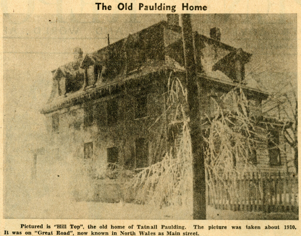
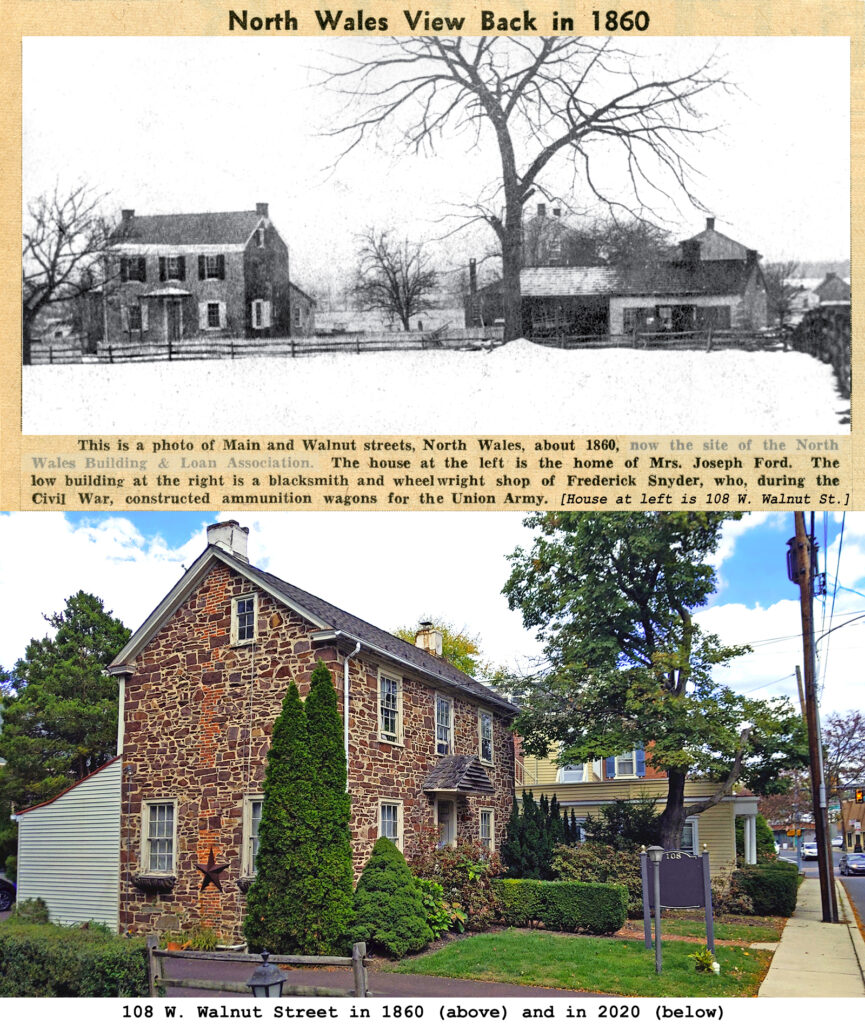
The dwelling, which stood on the site of the Benjamin H. Miller home, was built of stone with a rear wing, and was quite close to the highway. The stone barn was to the rear. The dwelling, though having a modern appearance, was quite old, but was remodeled by Mr. Paulding. The stone walls of the house had a yellow coating of plaster and it is known that before 1840 Frederick Weber lived here as a tenant.
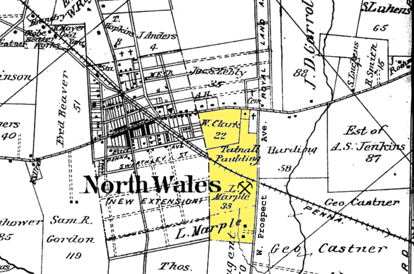
1893 map of North Wales with the Paulding,Clark, and Marple properties highlighted. The crossed pickaxe symbol represents the location of Hill-Top Quarry
This farm which earlier included the Marple farm across the railroad, is also a fragment of the patent of 720 acres confirmed in 1702 to Robert Jones. Just for the benefit of those future local historians who are showing such a great interest in these articles, we must repeat that this vast tract of 720 acres which belonged to Robert Jones extended across Gwynedd township for two miles from its northeast boundary, and was a half mile in width. It covered the site of North Wales and was held by Jones until his death 30 years later. He is supposed to have lived eastward of the present town at the George Jones place, or the present C. J. Fisher property. His will of 1732 conveyed to his son, John Jones, 300 acres upon which the latter then lived. His home was probably within the present borough, and was either northward of the present Rorer-Seems building or at the present apartment house at Shearer street and Pennsylvania avenue.
The Jones ownership finally ended in 1760, when John Jones and his wife, Gainor, sold 186 acres to George Weidner. All of this lay on the southwest side of the present Main street. The price was 546 pounds. Concerning what manner of man was this John Jones, who flourished here for three decades of the 18th century, we have no record. There is a record of the death of John Jones, carpenter, in 1775.
At some time prior to the Revolution George Weidner, who was a Lutheran or Reformed, had sold his plantation, or at least the greater part, to Jacob Wyant.
In 1776 Wyant was credited with owning 130 acres, 3 horses and 4 cows. In 1784 he sold off 29 acres of the southwest corner to William Rex. In 1776 Steven Bloom was credited with 35 acres, 2 horses and 2 cows.
In 1787 a property comprising 53 acres, which covered this tract and belonging to Daniel Boone, a blacksmith, was seized by the sheriff and sold to John Roberts. This, or at least part of it, had been, before 1780, a part of the estate of Philip Heist, who in 1776 had 120 acres. In 1795 John Roberts added seven acres, having bought them from the administrator of Hugh Evans. This lot probably lay southwest of West Prospect avenue. This purchase gave Roberts 62 acres. It had no improvements and was bought for 70 pounds. Hugh Evans had gotten it from his father, Thomas Evans, who died in 1784 and he, himself, died in 1789.
John Roberts was the owner of the farm for 11 years, or until 1798 when he sold to Philip Summers, of Gwynedd, for 65 pounds. This was bounded on the southwest for 48 perches of land of Rees Harry and Philip Hurst, on the northwest for a half mile by lands of Philip Hurst to the Great Road [Sumneytown Pike], and by the Road on the northeast side 49 perches; on the southeast side by lands of Martin Schwenk and Thomas Evans for 186 perches. It was a long narrow strip that Summers bought. It was later surveyed to contain 64 acres.
Philip Summers was the grandson of Hans George Summers, an emigrant, who arrived in Philadelphia from Germany in 1754 along with his wife Barbara Maria. Philip Summers and his wife were members of the old Yellow Church, North Wales and were Lutherans. Three of their sons were elected trustees, deacons and elders. They were Martin, Philip, Jr., and John. This Philip died on May 6th, 1814. His wife lived to be quite old, or until 1838. The second Philip Summers was the purchaser of the Gwynedd farm in 1798 from John Roberts and of which he was the owner for 29 years. He sold to John Robinson on March 20, 1827. He then removed to Philadelphia where he died on June 3, 1834.
The later history of this property is one of many changes of ownership which can only be briefly mentioned. The Marple and Paulding places continued as one farm for a long period of time. Robinson held it for a dozen years. In 1839 he sold to Daniel Miller. In 1852 Miller sold to Peter Wells Moore. In 1857 Moore was living in Upper Merion when he sold to Lawrence Corson, a real estate dealer of Norristown, the 62 acres. The North Pennsylvania Railroad [today the SEPTA Lansdale line] had cut the property in two 1856. In 1859 Corson sold to J. Sigmund Reichle for $4500. In 1862 the latter sold the 56 acres back to Corson for $4100. Next year Corson gave title to Jacob Mathias who conveyed to Charles Snyder in 1864.
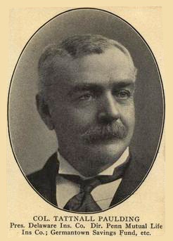
By this time the Marple farm had become detached. So in 1865 Snyder sold the 21 acres on the east side of the railroad to Clarinda Reeve, of Philadelphia, for $2100. The same year she sold to Mathias Schwenk for $2475. Mathias Schwenk came to stay, and there were no more changes for 17 years. In 1882 he sold to Sara Jane Clark for $5000. He had built a new house. Finally in 1890 Clark sold to Col. Tatnall Paulding, Civil War veteran and prominent businessman residing in Germantown. Paulding the same year bought a lot adjoining the 21 acres, having a house on it, from William J. Clark for $1000.
Mr. Paulding named his farm the Hill-Top Farm, and in June of 1892 he also operated the Hill-Top Quarry which was on the south side of the railroad and a short distance west of West Prospect avenue, at which place he sold stone for building, paving and curbing. The remains of this quarry can still be seen today [1959]. In November of 1892 the Reading Railroad ran a switch into this quarry to facilitate the shipment of stone to Philadelphia. In March of 1895 the Reading Railroad Company ordered all work in the quarry discontinued because of the blasting, at which time stones were thrown upon their tracks causing damage to passing trains.
Tatnall Paulding died March 3, 1907. His farm remained idle until May of 1912, when it was sold to Dill & Fenstermacher for development purposes.
This post is sourced from a column entitled Early North Wales: Its History and Its People penned by long-time North Wales resident historian Leon T. Lewis. The article appeared in its original form in the April 21, 1959 issue of the North Penn Reporter.
In part 5 we said we would devote part of this article to Jacob S. Zebley. So, here it is, quoted directly from the obituary column of the North Wales record under date of March 5, 1904.
“Jacob S. Zebley, a well known resident of Upper Gwynedd, died at his home on the Spring House and Sumneytown Turnpike, near North Wales, on Thursday, March 3rd, in the 90th year of his age. Mr. Zebley was one of our best known and most eccentric citizens, and will long be remembered for the wonderfully clear and accurate stories of days long gone by with which he delighted to entertain his willing listeners. While at all times he displayed a keen interest and appreciation of the history and politics of the present, nothing gave him so much evident pleasure as to regale some of his friends with glowing descriptions of the old merchants and operatic stars of the past, and to picture the joys and adventures of a voyage to South America in the early part of the last century [1800s].
“Mr. Zebley was a man of fine moral caliber, an unswerving friend, and a business man of ideal integrity; his word was absolutely as good as his bond at all times. He was a man of most sincere hospitality, and those who have had the pleasure of meeting him at his table can never forget the feeling of welcome with which his manner filled them.
“The name of Zebley was originally Zebli, but has been variously written Zubely, Zebley and Sibley. The family of Zubli was in a flourishing condition as early as the 16th century, at Berne, Switzerland. During some of the religious commotions of that century a part of the family passed into the low countries, and thence to America—this branch being represented by a Jacob Zubli who was born in 1610, at Berne, and who in 1638 emigrated to this country, and settled on the Delaware. His grandson, Jacob Zubley, 3rd, was born. in 1693, and married an Elizabeth Neff. They were both members of the German Reformed Church at Germantown. Their son Jacob Zebley, 4th, was born in 1733 and died in 1796. He was one of the founders of the Frankford German Reformed Church, and owned and farmed that ground upon which the United States Arsenal now stands. In 1761 he married Ester Madeira. Among other children they had a son Jacob Zebley, 5th, born in 1763, and baptized in the Germantown German Reformed Church. In 1787 he married Wilhemina Hess, and to them were born 13 children. In 1806 he married his second wife Arnie, who bore him five children, among whom was the subject of our sketch, Jacob Seman Zebley.
“Mr. Zebley was born in Union street, Philadelphia, in 1813. His father was a soldier in Washington’s Army, and a wheelwright by trade. He was high Constable of the City of Philadelphia – a chain presented to him bears the date of 1809 – and afterward held a position in the Custom House. Many of Mr. Zebley’s best stories related to those days, when his father chased audacious smugglers as far as Lancaster, and brought them back in a coach and four horses to suffer durance vile in the old prison at Third and Walnut streets, Philadelphia.
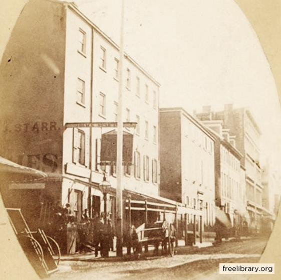
“Mr. Zebley’s early education was taken care of by one of the old time school masters who vigorously wielded the rod of birch, and rapped into unwilling heads the mysteries of the three R’s, by name Johnathon Palmer. In 1830 at the age of 17 years, the sight of the lonely Delaware so quickened in him an inborn love of the sea, that he persuaded his Uncle Captain Cowpland, of the Brig Ashman, bound for South American ports, to take him along on the voyage. Returning safely from this voyage, the Captain, upon being requested to let him take another, gruffly told him he was better fitted to pick rags, meaning to enter the mercantile business. This advice was kindly taken, and for several years Mr. Zebley was a clerk in a dry goods store in Strawberry Alley, Philadelphia, working 14 hours a day, with plenty of work in each hour. Later on he became one of the firm of Zebley, Chevalier & Company; doing business on Market street between 4th and 5th streets: this was about 1840.
Jacob Zebley’s dry goods store was located on Market Street between 4th and 5th Streets in Philadelphia. This photo was made about twenty years later [1859 photo by F. De B. Richards, Free Library of Philadelphia]
“In 1839 he married Sara Smith Willis, of Jericho Long Island and removed to Eleventh street, below George—now Sansom street, Philadelphia. Here two children were born to them, Emilie Seaman Zebley in 1840 and Sara Willis Zebley in 1842. The latter died in 1849, the former died in North Wales in 1899. About 1850 Mr. Zebley accepted a position with George S. Stuart & Company, in New York, and became their European buyer, making several trips to England and the Continent. It is probable that at this time Mr. Zebley was one of the best known and most successful salesmen in New York. He was afterward connected with the firm of Libby, Graef and Company and the well known Schuable Brothers of New York. During war times the high tariff put upon imported cloth, shawls and so forth, entirely ruined the business with which he was so well acquainted, and having laid by a modest competency he bought a comfortable home in Elizabeth, New Jersey, and removed there in 1867.
“Then Mr. Zebley became farm hungry, and for ten years he hunted far and near to find one to his liking, until one cold, snowy day in 1879 lie found, very much to his surprise, that he had bid on one in Gwynedd, and had it knocked down to him. For 25 years he gave his love to that farm, and no man ever enjoyed more the coming of the beautiful yellow corn than did be, and many were the days of pleasure he had in sorting out the noblest ears, and carefully piling them up as seed for the following year.
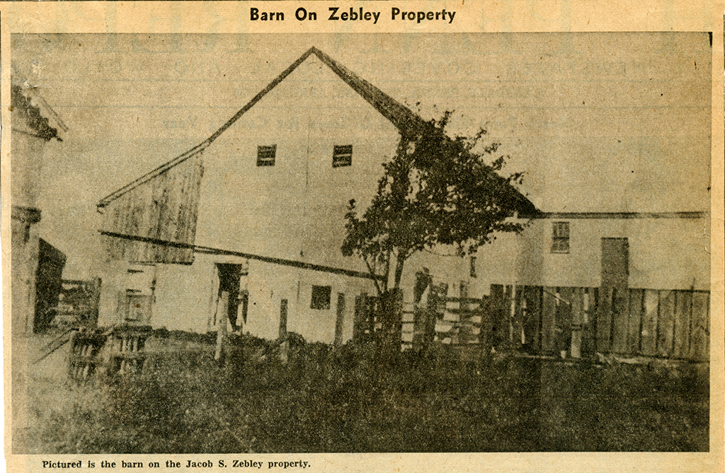
No longer standing, the barn on the Zebley property stood on the south (west) side of 2nd Street between Summit Street and Prospect Avenue
“The death of his daughter, Emilie, in 1899, was a great loss, and only the tireless attention and devotion of his adopted daughter, Louise Zebley Smith, enabled him to live through what would have been in his advance years an unbearable change of life. The one thing Mr. Zebley feared above all others was change. Many will recall how he stormed and protested when he was told that his farm was to be taken into the Borough of North Wales [the borough would annex that portion of Upper Gwynedd Township in 1910, six years after Zebley’s passing]. Had that [annexation] been done, or any other great change of living brought about, he would never have reached the ripe old age of 90. Until the last few years Mr. Zebley was a most faithful member of the Episcopal Church, Gwynedd, and for years held the office of Rector’s Warden. In politics he was an out and out free trader, until during the second term of [president Grover] Cleveland. Rents took such a drop that he thought it was time for him to do what he could to bring back national prosperity, and so from then on he always voted the Republican ticket.
“In Mr. Zebley, Gwynedd has lost a citizen of the type that is only too rare, and a land mark which cannot be replaced.”
This post is sourced from a column entitled Early North Wales: Its History and Its People penned by long-time North Wales resident historian Leon T. Lewis. The article appeared in its original form in the April 14, 1959 issue of the North Penn Reporter.
The borough of North Wales is situated in central Montgomery County, about twenty miles northwest of Philadelphia. Completely surrounded by Upper Gwynedd Township, it is located on the west side of a moderate incline that slopes downward from an elevation of 450 feet above sea level at the borough’s eastern limits to 350 feet at the western limits. The central business area has an approximate elevation of 370 feet.
SETTLEMENT
The area in which North Wales is located was originally settled primarily by Welsh immigrants. Early records indicate that the first settlers established their homes in 1698. The area at that time was variously called Gwynedd, Gwineth, or North Wales Township. All of these names derived from the region of Wales from which the settlers had emigrated. In 1702 Gwynedd Township was established. The township, primarily agricultural, remained populated by the Welsh in the southern and central regions, but before 1750 several Dutch and German families had located in the northern end. North Wales appears to have been the dividing point between the two settlements. A Lenni Lenape Indian trail traveling from the northern areas of Montgomery County to the Delaware River passed directly through Gwynedd Township and the area later to become North Wales. This early trail determined the lines along which the Great Road was laid out in 1728. (This highway, now known as Sumneytown Pike, passes through North Wales as Main Street.) By 1850 improvements to the road were made by a private turnpike company that charged tolls of the horse-drawn traffic making its way to and from the markets of Philadelphia. A cluster of farms, a distillery, and a church occupied the present site of North Wales. In 1857 the North Pennsylvania Railroad, which had been delayed over a year by the construction of a tunnel in Gwynedd Township, was completed. Built to carry people, goods and anthracite coal between the Lehigh Valley and Philadelphia, the North Penn created a stop, named North Wales, where the railroad intersected with the Great Road. This intersection of two major transportation arteries attracted tradesmen and businessmen.
ESTABLISHMENT
In 1868 a petition was filed with the Montgomery County Court, requesting the incorporation of the settlement into a borough. The following quotation extracted from that petition (in the Court House) gives an idea of how quickly this hamlet developed and prospered in those first few years after the arrival of the railroad.
“. . . that Village is a thriving, growing, rapidly increasing, and active business town, containing a Depot, Lumber Yard, Coal Yard, three General Stores, Drug Store, Boot, Shoe and Trunk Store, Feed Store, Flour Mill, two Hotels, Restaurant, a Saddlery, Harness Makers, Shoemakers, Blacksmith Shops, Wheelwright Shop, Steam Moulding Sash and Door Manufactory, Brick Kiln, Churches, School House, Conveyancer, Real Estate and Insurance Offices, a Building and Loan Association, Library Association and other institutions of learning and usefulness, and about three hundred and eighty inhabitants, sixty-five of whom are freeholders.”
1868 petition filed with the Montgomery County Court, requesting the incorporation of the settlement into a borough
On August 20, 1869, the court decreed in part that “the said town of North Wales be incorporated into a borough. . . .That the corporate style and title thereof shall be ‘The Borough of North Wales.’ ” This was the first borough incorporated by the Montgomery County Court, the preceding four boroughs in the county having been created by the state legislature.
PHYSICAL GROWTH
The original borough, roughly square, encompassed about 100 acres. An almost equal amount of territory adjoining the southwest boundary was annexed into the borough in 1884, raising the total area to 195 acres. An additional 192 acres was annexed to the northeast boundary in 1910. In 1935 a small tract of about 12 acres was ceded to Upper Gwynedd Township [the northwest corner of E. Walnut Street & Beaver Street]. The most recent increase was in 1958, when a tract of about 14 acres was added along the southeast boundary.
In the first decade of its growth, or until 1880, population steadily increased, to 673. The problems facing the borough government were many. Lack of money to operate was one of the most pressing problems. The borough often borrowed funds from several citizens. Even at this early time residents demanded more and better roadways and lighting.
The North Wales Record, a weekly newspaper published from 1874 until 1942, spread the word that the town was rapidly growing. In 1890 the population was 1,060, and advertisements in the newspaper showed that many small businesses were active.
By the turn of the century North Wales had reached the high point in its growth rate. The population in 1900 was 1,287, more than triple the population only thirty-one years before.
Two large textile knitting and weaving mills, a large asbestos-processing mill, an iron foundry, and a grain-processing mill were the large employers around 1900. Still surrounded completely by farms, North Wales, with its concentration of several mercantile stores and many tradesmen, was the main shopping area for several miles around. Much of the daily traffic was created by the farmers bringing their loads of grain to the mill on Main Street, and driving herds of cattle through the streets to the cattle-loading pens for the railroad on Walnut Street.
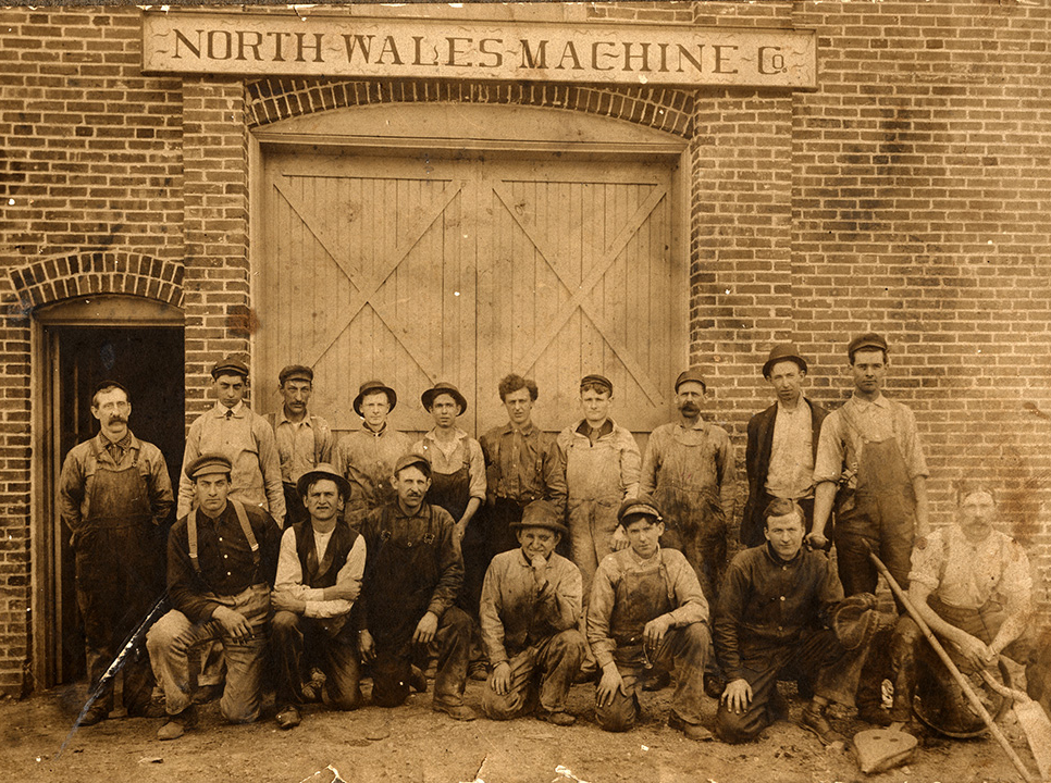
In 1909, North Wales Machine Company was located at 320 Elm Avenue.
The fifteen years from 1885 to 1900 probably saw more improvements to the town than any other period. In 1885 a privately owned water distribution company was formed. This company drilled its own wells and laid pipe throughout the town and the area immediately outside it. It continued to supply water until 1951, when the borough of North Wales purchased it.
Another private company formed about 1896 to generate and supply electricity. Electric street lights were first used in 1897. A generator located in the rear of the flour mill on Main Street provided current. Later a larger generating plant was built at Third Street and Montgomery Avenue, and it remained in operation until the company was sold about 1911.
Also during this period telephone service arrived. A directory of 1901 listed sixteen local phones and two private lines. The first trolleys passed through town in 1901, and service continued until 1926, when buses replaced the trolleys.
By 1915 the town government had begun to install a sanitary-sewer system, which went into service in 1917. The collection and treatment operations worked solely by gravity and water flow power, requiring no outside source of power and little manual maintenance. This system, although modernized, remains in use today [1980].
It is not widely known that North Wales was once a summer resort area. From about 1870 through 1915 several large homes and the three hotels in town (mentioned below) catered to people who wished to escape the heat of the city and spend the summer in the more pleasant and quiet countryside.
During the second thirty-year period of its existence, the borough continued to grow but at a less rapid pace. By 1930 the population had reached 2,393. After World War I the modern technology of the rapidly advancing machine age began taking its toll on the borough’s larger industries. This, coupled with the great financial crisis in 1929, resulted in the failure of many small businesses and the reduction of employment in the larger mills.
Recovery from the Great Depression during the 1930s and the prosperity after World War II did little for industry in North Wales. However, it was during this period that industry, formerly city oriented, began to move to the suburbs, and the township area outside the borough began to grow. As industry receded, the borough began to emerge as a residential area; the population grew to 3,673 in 1960. Housing spread to the limits of the borough and spilled out into Upper Gwynedd Township. In 1950 the Borough Council took steps to control development by adopting the borough’s first Zoning Code. This code remained in effect until 1977, when a new and far-reaching code was adopted to coordinate with the county comprehensive planning program.
NORTH WALES WATER AUTHORITY
In early years a great many of the less than seven hundred residents obtained their water from a hand pump over a large well located beside the Main Street Hotel [on Main Street opposite Shearer Street]. The North Wales Water Company, formed in 1885, distributed and sold water in the borough and the immediately adjacent township area. Borough residents not served by the company relied on their own wells.
In 1951 the Borough Council created the North Wales Water Authority. The authority then purchased the water company by means of a $238,000 bond issue to be paid off entirely from the revenues of the water system.
As the postwar industrial and residential growth boom continued in the region, the North Wales Water Authority kept pace. From 1,100 customers, who required an average of 272,000 gallons per day in 1951, the authority in 1980 used about 173 miles of underground pipe to supply a daily average of over 5 million gallons to more than 10,400 customers in six townships and the borough.
COMMUNITY SERVICES
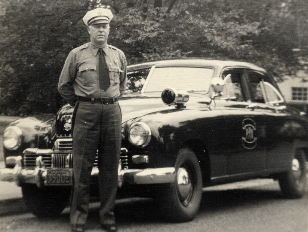
The North Wales Police Department was created by order of Borough Council in 1903, when one man was hired to serve as a full-time peace officer. Before that, police duties had been handled by constables who were called upon as needed. Norman Chestnut, police chief from 1930 to 1938, took the first step toward modernization when he obtained a motorcycle for patrol. The first patrol car was supplied to H. W. Turner, chief from 1938 to 1943. Chief Turner was also responsible for the installation of radio communication with the county radio system. Edward Veit, chief from 1943 to 1966, urged the council to hire an additional patrolman, that position first being filled by Joseph Whitley in 1944. Whitley was promoted to chief upon Veit’s death, and held the office until his death in 1973. The present force, under the direction of Kenneth Veit since 1973, consists of four men supplemented by part-time patrolmen [1980].
Long-time North Wales police chief Edward W. Veit. The patrol car is a 1947 Kaiser Special.
Fire protection is supplied by the North Penn Volunteer Fire Company, which was organized in 1930 in North Wales. Before then, the borough had a municipal fire company and associated equipment. The men were paid only for time spent fighting fires. The inability of the council members and the firefighters to agree on the type of equipment and operational methods caused the dissolution of the borough-controlled department and the creation of the new volunteer company. Today this well-trained and well-equipped organization is totally volunteer and operates with funds received from private donations and grants from local municipalities.
The North Wales Memorial Free Library, located [in 1980] in the elementary school building on Summit Street, is also a volunteer organization that operates on private donations and government grants. The library was founded in 1923, primarily through the efforts of the Woman’s Civic Club of North Wales, and supporting the library has been an ongoing project of the club ever since. An unsuccessful attempt had been made to form a library in 1885, when the Union Library operated in the second floor of a small office at Fifth and Walnut streets. Lack of support and interest ended this effort, and after only a few years it was abandoned.
SCHOOLS
A small building located at the southwest corner of Main Street and Elm Avenue served as the public school until a large two-story brick building was erected in 1887 on School Street between Third and Fourth streets. Some years later the school acquired a three-story addition to the front of the building. This building served as the only school for both elementary and high school until 1928, when a new high school was opened on Summit Street. The older school continued in use for elementary education until 1954, when it was sold to the borough and converted into a municipal building. The Summit Street building became the elementary school; the high school students were absorbed into the North Penn school system.
The North Wales Academy and School of Business was opened by Samuel Brunner in 1871 in a building on Main Street, and moved to larger quarters on the southeast corner of Pennsylvania and Montgomery avenues in 1872. This school, also known as Brunner’s Academy, offered business courses and college preparatory work. The date of its closing is uncertain but is believed to be the early 1900s.
Saint Rose of Lima School, built in 1954-56, opened its first classes in 1956 to serve the parishioners of the church mentioned below.
HOTELS AND PUBLIC BUILDINGS
Three major hotels were located in the borough. The Main Street Hotel (sometimes known by the names of its proprietors) is the oldest, having been rebuilt from a farmhouse and distillery in 1857. Located on Main Street at Lumber Street, it is used today as offices and apartments. In the rear of the hotel, on Second Street, is a two-story brick building that served as the public livery stable for the hotel. During the early 1900s the building was remodeled, and the second floor was used as a public meeting hall and lodge home.
The Central Hotel on School Street at the railroad station was built some time before 1868. This hotel contains apartments today, but continued to serve the traveling public until well into the twentieth century.
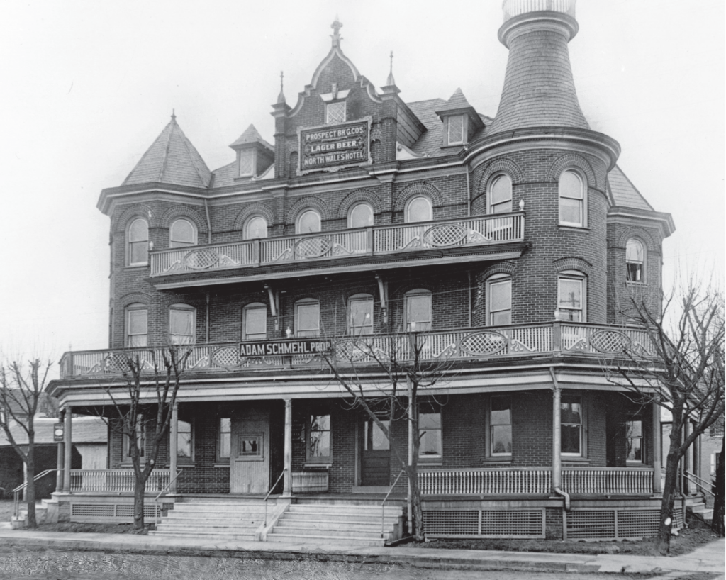
This 1890s photograph captures the impressive appearance of the Colonial Hotel on the corner of 5th & Walnut Streets. The building’s final incarnation as McKeever’s Tavern came to a close in 2014.
The third, the Colonial Hotel at Fifth and Walnut streets, was erected in 1893 and continued in use as hotel until 1974, when it was converted to a restaurant and tavern. It was an ornate four-story brick building and one of the fanciest in the area at its time of construction. It also had a public livery stable. In more recent years before its closure in 2014, it was home to a much-loved community gathering place, McKeever’s Tavern.
Amusement Hall was for many years the borough’s social center. The front portion of the hall was a three-story frame building on School Street between Third and Fourth streets [across from Borough Hall]. Extending from the back portion was a one-story auditorium that was reported to seat over five hundred people and included a stage. The hall was built in 1887 demolished in 1937. It was the scene of plays, graduations, basketball games, roller skating, public meetings, and cinema. The portion of the hall facing School Street was remodeled into twin houses, which still stand today.
Construction of the Municipal Building began in 1959, and the dedication was held in June 1960. The borough had obtained the land and the old School Street school building after the school authority had decided that the building was no longer suited for school use. The borough then transferred title of the property to the North Wales Water Authority, which designed and built the Municipal Building. The design removed the school’s third floor and front tower, but did incorporate some portions of the original building. In 1978 the borough purchased the property from the water authority, which had used part of it, and it is now used solely for the administration of the borough.
WEINGARTNER MEMORIAL PARK
Upon his death in 1944, John Weingartner bequeathed funds to the borough to purchase, develop, and maintain a park. Weingartner Memorial Park, created and dedicated to the memory of John and Carrie Weingartner in 1954, covers a nicely landscaped tract of about three acres on Summit Street across from the North Wales Elementary School. Weingartner Park is frequently the site of civic gatherings, musicals, and memorial services.
CHURCHES
A log cabin on the site of the present Lutheran Cemetery at Main Street and Prospect Avenue was the first home of both the Lutheran and the Reformed congregations from the middle 1770s until 1815, when it was destroyed by fire. A second church, built at the same location for the continued use of both congregations, was a stone building seating over five hundred people. The exterior, plastered with yellowish or cream-colored plaster, gave rise to the nickname the “Old Yellow Church.” In 1868 each congregation built its own house of worship in North Wales.
St. Luke’s United Church of Christ (formerly the Reformed) congregation demolished its 1868 church and replaced it with the present church in 1909.
The Lutheran Church on Main Street, although modified, is still the original structure.
The North Wales Baptist Church built its first structure on the Allentown Road on the site of the present Baptist Cemetery in 1861. This was known as the Gwynedd Baptist Church. In 1874 the congregation built the church on Shearer Street. Portions of the original building are included in the present church.
In 1870 the Methodist Church was constructed at Fourth Street and Montgomery Avenue. It acquired an upper room in 1880 and a large stone addition in 1917. In 1966 the new Sanctuary United Methodist Church was built in Upper Gwynedd Township, and the old building in North Wales was sold.
The St. Rose of Lima Catholic Church became a reality in 1915 after the parishioners had held their worship meetings for over two years in the upper floors of the planing mill on Main Street [next to today’s fire house]. The original church was never completed as originally projected; only the basement section was used for services. In 1966 the present church building on Main Street was dedicated, and the old building was used thereafter only for various meetings and functions.
POSTAL HISTORY
North Wales post office was established on May 2, 1864. Isaac Freed served as the first postmaster.
A 1980 PERSPECTIVE
North Wales Borough, predominantly residential, has a generally middle class, ethnically mixed population of 3,391. Many families living in the borough and the township trace their ancestry to the original Welsh and German settlers. The business community consists primarily of professional offices and a few small stores serving the residents of the area. Industry, which once heavily supported the borough, has mostly moved away from its limited confines to open areas where expansion does not create a problem. Only a small amount of industry remains within the borough.
Leon T. Lewis, Jr. Historian 1980
BIBLIOGRAPHY
Geisinger, John B. The Schools of North Wales. Published by the Donald McLeod Post 336, American Legion, 1941.
Lewis, Leon T. Facts about Early North Wales. Published by North Wales 85th Anniversary Committee, 1954.
Lewis, Leon T., Jr. North Wales, Its Birth—Adolescence—Maturity. Published by North Wales Centennial Cele-bration Committee, 1969.
Maag, Mrs. Andrew. A Short History of North Wales. Published by the Donald McLeod Post 336, American Legion, 1941.
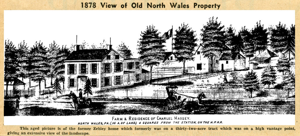
The buildings on the former Zebley property were on the top of the hill on the southeast side of North Wales.
Here was a two story stone and brick house, plastered on the outside, close to the northeast side of Main street and well surrounded by shade trees. A lane was at the side of the house which lead to the barn in the rear. This was a farm of 32 acres, but it had been largely cut up into building lots and dwellings erected thereon. This farm formerly extended along the summit of the ridge to the crossroads, or the extension of Fifth street, while the lower boundary was the road (Prospect avenue), passing the Lutheran Cemetery.
The Zebley property was on the east side of S. Main Street between Highland and Prospect Avenues
The farm comprised two tracts, one of twenty acres nearest the buildings, and one of twelve acres, composed of several smaller tracts.
On one of these near the lower road, or Prospect avenue, up until 1904 stood an ancient log house of one story, which was burned down in that year. From this point a most extensive view of the landscape, far to the north and northwest, and also to the south, can be obtained. This hill is a part of a high ridge extending across the country from the Delaware to the Schuylkill, only dipping down to allow the passage of streams, such as the Neshaminy and Wissahickon. Closely adjacent the Reading railroad passes through it by a deep cut.
This property is a fragment of the great tract of 720 acres, granted in 1770 by William Penn to Robert Johns, who was then one of the sixteen grantees to the whole township. of Gwynedd. This tract extended across the whole width of the township. He lived near the Kneedler tollgate, on the road running to West Point, where he built a house in 1712. His will of 1732 gave this to his son, John Jones.
At what time improvements were made on the top of the hill is not known. In 1758 Abraham Lukens bought 120 acres of John Jones, covering the site of North Wales. Prior to the Revolution, or in 1772, Lukens sold the same to Philip Heist, a German. In 1758 he had also sold 80 acres to his son, Abraham Lukens, Jr., and of which, in 1772, the latter sold 70 acres to Philip Heist. For all we know to the contrary he may have built a house here. His will was made in 1776, when he was the owner of 120 acres. A Welshman named Humphrey Hughes bought the most of this, or a house and 100 acres, in 1780. He paid, in inflated Continental currency, the sum of $16,800 pounds. In 1776 the assessor taxed Philip Heist for 120 acres, two horses and four cows.
The site of the Zebley house, and the lane surrounding it, was certainly a part of a tract of 20 acres sold to Matthias Booz, in 1781, by the executors of Philip Heist, and it was there that Booz, or Boaz, lived. He paid only 170 pounds for the tract and may have built the first house. These 20 acres were surrounded on the northwest side for 43 perches by land of Humphrey Hughes, also by land of Hughes on the northeast side for 78 perches.
On the southeast was the land of Martin Schwenk for 31 perches and the Lutheran Church lot, or Cemetery. The Great Road, or Main street, ran past it on the southwest for 32 perches.
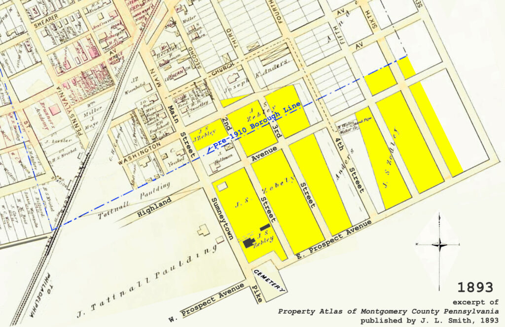
Yellow shading highlights those portions of the Zebley tract that remained in 1893
Matthias Booz was a young man when he came here and he spent a long life thereafter on the top of the hill, where he lived for over forty years, or until 1823. He left at least three sons, Jacob, Samuel and John. The two former, as their fathers executors, sold the property to their brother, John H. Booz. The deed was not given until 1839. John H. Booz held the property until 1858. In that year he sold the farm to Silas C. Land, for $4000. The latter died without will, in January 1863. He left minor children for whom Jacob Acuff was made guardian. In 1863 Acuff sold the property, now increased to 32 acres, to David Smith, of Philadelphia, for $5700. During his ownership Silas Land had built a new brick house.
In 1870 David Smith conveyed the property over to his wife, Amanda Smith. They were the parents of Harry Smith, an early publisher of The North Wales Record. The next owner was Charles Massey, who bought the property in 1878. He was a painter and glazier and also came from Philadelphia. The next year, in 1879, the latter gave deed to Jacob S. Zebley, who came from the city of Elizabeth, New Jersey. The price was $6000 for the 32 acres. Zebley lived here for a quarter of a century, reaching the very advanced age of 90 years. His death took place on March 3rd, 1904. The house and seventeen acres were then sold to Andrew H. Tyson, who remodeled the house and lived in it until his death several years ago, after which it was occupied by his widow, who remained there until her recent death, when it was sold on January 10, 1957, to George B. Burpee, the present occupant.
John Booz was born July 1, 1790, and died August 23, 1871. His wife, Margaret, was born April 14, 1797, and died March 1, 1863. Both are buried in the Lutheran Cemetery.
Both Silas Land and wife died of spotted fever in January 1863. He being 46 years of age, while his wife was about 40 years of age.
All of the present houses between Summit street and Prospect avenue, and between Main street and Eighth are built upon the ground of this Zebley tract. The present North Wales Elementary School, and its adjoining grounds, occupies a large portion of this original tract.
It being the purpose of these articles to give the history of North Wales and its early residents, we feel it is proper at this time since we have just given the history of the Zebley farm, to relate the background of Jacob W. Zebley, who was one of the most colorful of our early residents. Therefore next week we will devote part of our article to Mr. Zebley.
Thispost is sourced from a column entitled Early North Wales: Its History and Its People penned by long-time North Wales resident historian Leon T. Lewis. The article appeared in its original form in the April 7, 1959 issue of the North Penn Reporter.
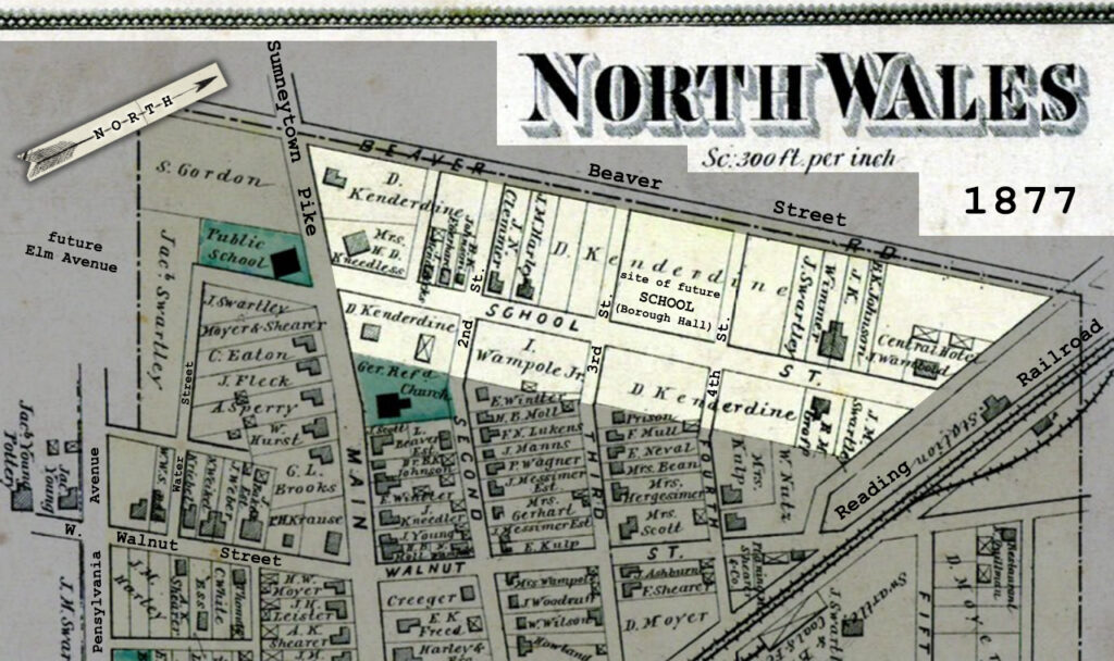
We will now take up the Kenderdine property which occupied a considerable portion of the present borough of North Wales, now covered by streets and houses. It was a strip of twenty acres, extending from Main street along School street northwest to beyond the railroad station.
On this tract stood Amusement Hall, the public school building which is still standing [now borough hall], the Central Hotel [apartment building at 428 School St.], the railroad station and many dwellings. On a large lot bordering School, Main and Second there stood a brick dwelling. Up to this time, Daniel Kenderdine had been a successive owner. A building probably stood here many years before the Revolution. A convenient spring of water was close at hand.
In shape, this tract was 452 feet wide on Main street, 2485 feet (nearly half a mile) in length, but only 396 feet wide at the northeast end.
In the beginning about one half of this tract was covered by the grant of 720 acres to Robert John in 1702, and by him conveyed by a will in 1732 to his son John. The upper side, next to the former Beaver farm, was part of the Evan Pugh patent of 1048 acres. Of the latter 185 acres had been bought by Cadwallader Foulke, by Robert John and which John Jones also received by will.
Excerpt of 1877 atlas with what remained of the the Kenderdine Tract highlighted
After nearly a quarter of a century, John Jones began to break up his inherited estate. In 1755 he sold 108 acres including half of this to David Cummings. in 1788 Jones sold 158 acres to Abraham Lukens, and in the same year the latter sold 80 acres of it, upon which was a dwelling to his son, Abraham Lukens, Jr. Within this was the other ten acres.
In 1760 Cummings sold to George Morris. Morris was a speculator and only two years later, sold to Mathias Lukens. In 1764 the latter conveyed to Joseph Lukens ten acres. He had bought the other ten acres in 1762 of Abraham Lukens. Thus in 1762 the twenty acres first became a consolidated property, and would continue as such for over 100 years.
Ten years later, in 1772, Job Lukens bought the house and twenty acres.
Job Lukens was the owner during the American War of Independence, holding the property for fourteen years, during which troublesome times he was busy making saddles. In those days when there were few wheeled vehicles, this was the main work of the harness maker, for the horse was a widely used means of transportation.
Then in 1786 along came a weaver from Solebury, Bucks county. He had an English Quaker name, common in that county, but then unknown in Montgomery. This was John Hampton, who gave 200 pounds, or $1000, for the little house and lot. There he worked his loom for six years. At that time the following were the adjoining land owners: Jonathon Clayton was on the upperside, Isaac Kulp, Abraham Lukens. The latter had ownership at the southeast side. The name of John Hampton is found in the list of Gwynedd Taxpayers for 1792.
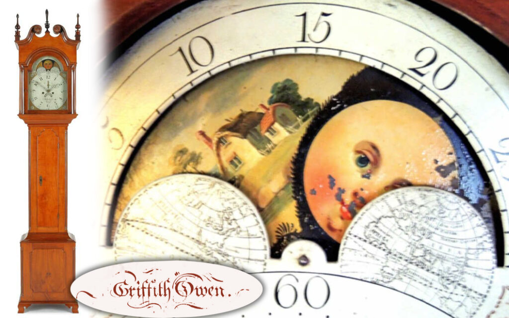
In 1792 John Hampton sold to Ezra Thomas for twenty pounds less than he gave or 180 pounds. Thomas was the owner four years and then sold to another Welshman in 1796, who was Griffith Owen. Owen was a famous clock maker and those tall old fashioned clocks came from his hands, now known as “Grandfather Clocks.”
Examples of North Wales clockmaker Griffith Owen’s fine work
At that time Jacob Dilcart owned the Main street tavern property together with a farm of 72 acres. It was no tavern then. It appears that Owen wished to obtain a spot from which flowed a spring, instead of carrying water from the spring of a near neighbor. So in 1803 Dilcart sold him a tract of land comprising ten perches for twenty dollars. In the same year Owen sold the whole property to another Welshman bearing his own first name for his last name. This was Doctor Amos Griffith. The latter was the son of Griffith Griffiths and was born in East Nantmeal, Chester county, in 1770. He gave 375 pounds for the property, or about $1800.
Griffiths ownership of this property lasted thirty-four years, or until 1837, when he sold to Anthony Barnhart. The latter was a wheelwright and worked in a shop which stood near the old house. in 1848 he sold the property to Daniel Kenderdine for $1300. The latter lived there for twenty-seven years and died in October 1875. From time to time portions of the original twenty acres were sold off for building lots [along School Street]. The remainder was long owned by the widow, Mrs. Lavina Kenderdine.
Mrs. Kenderdine died previous to 1896. In 1902 her executors sold the old house and lot where she had lived, to the North Wales Building and Loan Association for $3500. Since then the old house was torn down and two double brick houses built on the lot. These are the houses facing Main Street between School street and the Reformed Church [St. Luke’s]. The twenty acres once held by Mrs. Kenderdine had previously been lessened by the sale of several lots to various individuals, and to the North Wales School District. [The school district purchased eight lots, comprising the entire block bounded by 3rd and 4th Streets, School and Beaver Streets.]
Our next installment will discuss the Zebley farm and its connection with the borough.
Thispost is sourced from a column entitled Early North Wales: Its History and Its People penned by long-time North Wales resident historian Leon T. Lewis. The article appeared in its original form in the March 31, 1959 issue of the North Penn Reporter.
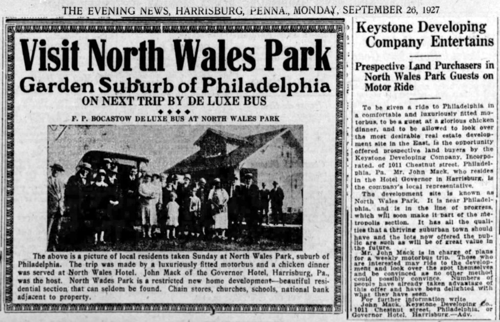
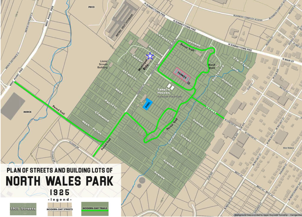
In 1925 Keystone Developing Company purchased and subdivided the 100-acre Gordon tract in Upper Gwynedd Township. The half-mile long southeast boundary line of the property butted up against the borough of North Wales. Keystone Developing Company wasted no time in carving the property into a grid of paper streets and hundreds of building lots to sell to prospective homeowners and investors. The nearby attractions of the neighboring borough, and the opportunity to commute by way of the electric trolley cars on Sumneytown Pike, were selling features.
On Sundays in 1926, 1927 and 1928 promoters bussed upstate people to a new development they called North Wales Park, with the promise of a sightseeing outing and complementary chicken dinner. Only two houses were built, on the southwest side of Center Street. One is pictured below. A water main was extended beneath Center Street from North Wales to serve the development. Neither house survives today.
Prospective lot buyers were bussed from upstate towns to the North Wales Park development. This photo is posed in front of the sample home on Center Street
At first, the developers offered reasonably sized building lots, but subsequent phases sliced blocks into narrow lots that were too small to construct a suburban house. Deeds to some lots were given away as “prizes.” Old-timers remember these being referred to as carnival lots or movie lots, because those were among the venues where titles to those properties could be “won.” In subsequent years many lots were subject to sheriff’s sale for nonpayment of property tax (amounts owed seldom exceeded $5). Deeds were forgotten in desk drawers; owners moved away or died. The addresses of myriad vacant properties refer to planned streets that were never built: Gordon Boulevard, Atlantic Avenue, Lafayette Avenue, and others.
Gordon Boulevard’s alignment can be hiked today, an earthen footpath alongside a single line of utility poles cutting a clear swath through the woods. Portions of Center Street and Parkside Place are today occupied by 10 foot wide paved trails.
By 1970, Upper Gwynedd Township had begun the painstaking process of tracking down and gaining possession of the patchwork of parcels, naming the new municipal complex Parkside Place — one of the original 1920s street names.
This drawing of the 1925 plan for the North Wales Park residential development is superimposed over a modern map. Upper Gwynedd Township’s Parkside Place municipal complex, recreation fields, paved trails, and the Nor-Gwyn pool occupy the site today.
The tradition of carnival and fireworks at Parkside Place goes back a lot farther than we may realize, back to the days when the developer had not yet given up on selling building lots. The July 10, 1930 issue of the Ambler Gazette reported that Independence Day fireworks were set off “promptly at 10 o’clock near the grove on the former Gordon farm and were very much admired by the big crowd from North Wales and nearby towns.” The article went on to say that no accidents of much account were reported, only “a small bomb in exploding broke the lens of a local resident’s eyeglasses, slightly injuring an eye.”
The Gordon tract, while not within the limits of the borough of North Wales, played an important part in the history of the town.
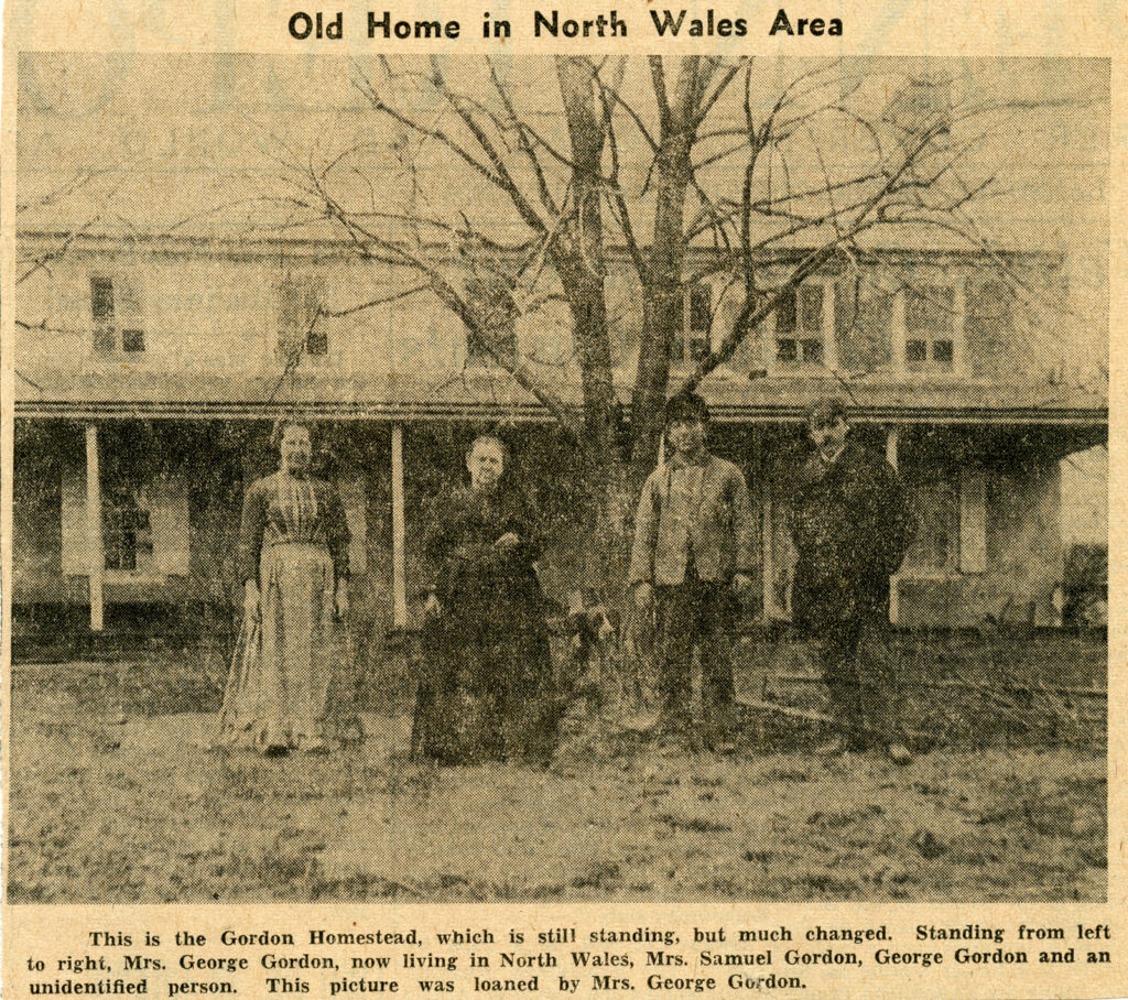
This large farm, adjoining North Wales immediately to the west, is today [2021] the location of Upper Gwynedd Township’s Parkside Place. The property belonged to the Gordon family for nearly forty-five years. The farmhouse and farm buildings were located some three hundred yards southwest of the Sumneytown pike [between today’s tennis courts and the creek]. Here was a large two-story stone house on the meadow bank. A large barn was situated just north of the house. Beyond was the orchard and farther northwest was a piece of woodland. A considerable portion of the property was meadow land adjoining North Wales. A small stream flows southwest, seeking the Wissahickon. In the olden days a lasting spring caused this site to be selected for a dwelling. The farmland is nearly level. The farm comprised over 100 acres, including a rented house and yard that occupied a portion of the frontage along the Sumneytown pike.
The Gordon homestead no longer stands. The location is today’s Parkside Place tennis courts
This is a fragment of the great tract lying across Gwynedd in early colonial times patented to the Johns, or Jones, family, whose homestead was at the Danehower farm on the road from Kneedlers to West Point [West Point Pike]. This was divided up into tracts. More than twenty years before the Revolution, this tract came into the possession of Cornelius Tyson, who sold about 120 acres in 1758 to Mathias Lukens. There had been buildings here long before that time. In 1761, Mathias Lukens sold to George Weidner, whose life ended in 1764. His will bequeathed this property to his son Abraham who immediately gave a deed to his brother Christian Weidner. The latter only held it four years, selling it in 1769 to Melchoir Weidner. The latter held it until near the close of the Revolution. He sold it in 1780 to Jacob Schwenk for 750 pounds Continental currency, or about $3700 for 108 acres. There were two Jacob Schwenks: Senior and Junior.
The death of Jacob Schwenk, Senior occurred before 1828. In that year the other heirs gave title to their brother Jacob Junior, for $1815 for 110 acres. The latter died in 1845. The Schwenk ownership lasted forty-six years.
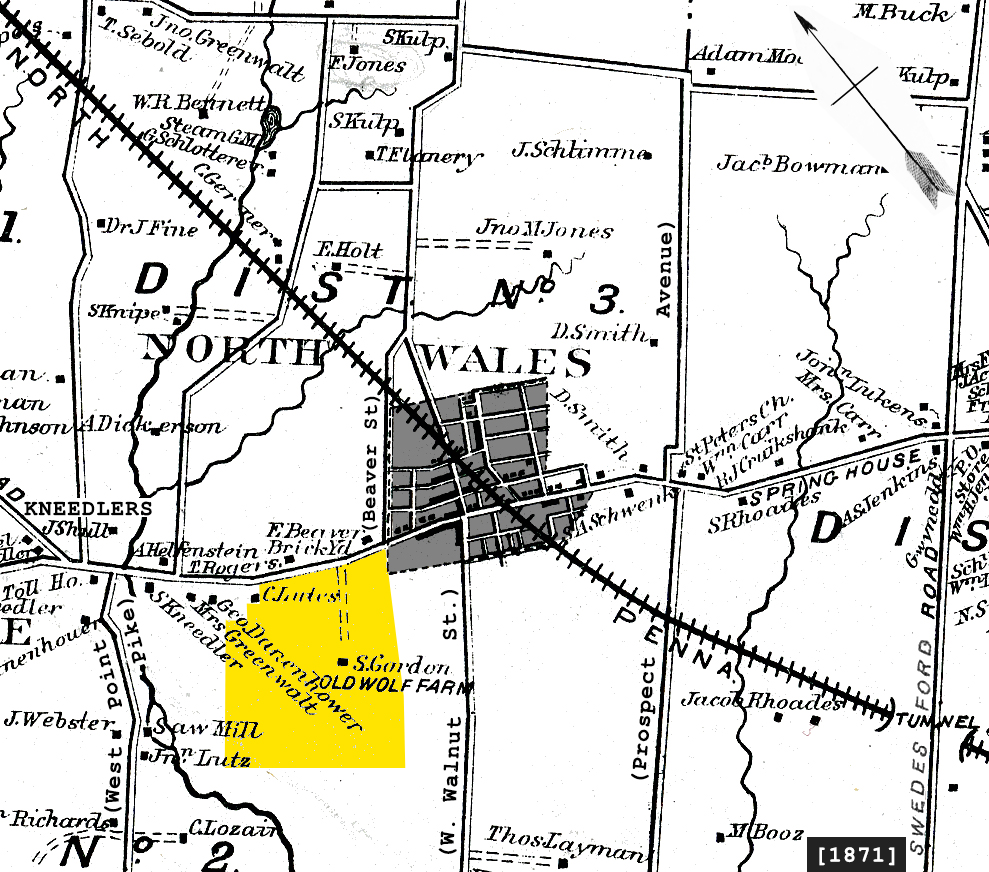
excerpt of 1871 atlas with the Gordon Tract highlighted in yellow
In 1846 the land that would become the Gordon farm was sold to Christian Markley for $6,029, who was a son-in-law of Jacob Schwenk. He was a man of some prominence, having served a term as director of the poor. His death took place during the period of the Civil War, or about 1864. At that time the farm was one of 120 acres. In 1864, the executors of Markley sold it to George W. Wolf, of Philadelphia. After a few years the latter became so involved in debt that the sheriff seized the property in 1869, and at the sale Samuel R. Gordon was the purchaser for $14,700.
Gordon thereafter was the owner for the remainder of his lifetime, lasting 26 years, and was widely known. The death of Samuel R. Gordon took place on May 27, 1895. His will gave $3,420 to his wife, Margaret. To his daughter, Mrs. Anne Englehart, was given a house and a lot of ten acres bordering the Sumneytown pike. This house still stands in a rather dilapidated condition, at the corner of Sumneytown pike and Dickerson road [since torn down].
His farm of 100 acres was left to his two sons, George and Walter Gordon, who were the owners of this farm until 1925. In that year George and Walter sold to a developing company, which promptly carved up the land into hundreds of narrow building lots and in which condition it remains thirty-four years later [1959].
The curious story of the Gordon Farm development, billed as “North Wales Park,” will be told in the next installment of this series.
This post is sourced from a column entitled Early North Wales: Its History and Its People penned by long-time North Wales resident historian Leon T. Lewis. The article appeared in its original form in the March 31, 1959 issue of the North Penn Reporter.
Before getting into the history of the village of North Wales after its incorporation as a borough, let us review some more of the history of the territory upon which the town now stands.
The Swartley farm, on which is situated a large portion of the dwellings in the southwest side of the borough, dates back to colonial times, the first mention of it being made in 1702, when, as we have said, Robert John was given a grant of 720 acres. Various subdivisions were made of this tract until 1786, when it was sold by the sheriff. In 1888, after the death of Jacob Swartley, it was cut up into building lots and sold. The borough was enlarged at that time and the greater portion of the farm was included in the borough.
The Swartley farm was a part of what had been known as the Hurst farm, all of which is now covered with dwelling houses. It extended from Main street southwest to a forest. At one time it comprised 134 acres, which was later reduced to 102 and then to 73 acres. The terrain was nearly level, gently sloping westward to the valley of the Wissahickon. The old stone farmhouse and barn was toward the northeast end where is now the corner of Pennsylvania avenue and Shearer street. The old farmhouse is still standing, but greatly altered and enlarged. It is now an apartment house.
The farmhouse, now divided into apartments and surrounded by houses, is located at Shearer Street and Pennsylvania Avenue
The history of this farm goes back to 1786. The tract had belonged to Jacob Weyant before that time, when it was seized and sold at sheriff’s sale by Sheriff Potts who sold 102 acres to Philip Hurst. There was a house on the tract at that time. Later Hurst added twenty acres, bought from Adam Fleck. Philip Hurst lived here for fifty-five years. In 1839 the administrators of Philip Hurst sold the 134 acres to Jacob Swartley and Jacob Shearer $5207. The land then extended for 137 perches (half a mile) along Main street.
Thirty years passed, and Jacob W. Shearer died in July 1869. He was the grandfather of our present [1959] businessman, Abel K. Shearer.
In 1879 the widow of Jacob W. Shearer gave a deed for the tract to Jacob Swartley, and he was the owner until his death in December of 1885. By this time property had greatly advanced in value. At different times portions of the old farm were sold. The old farmhouse, and nine lots adjoining, were sold in 1888 by Mahlon R. Swartley, son of Jacob, to Herman Hamburger, a manufacturer, who had come here in 1879 and opened a factory. The property was owned by the Hamburgers for thirteen years. In 1901 Madge E. Hamburger sold the place to Thomas K. Smith. The next year it was sold to Walter G. Smith, who sold it in 1910 to William R. McDowell for $5300. It then passed through various ownerships until October 1939, when it was purchased by H. LeRoy Jones.
Concerning the earlier colonial history of the entire tract, it may be said that the first owner of the land in the upper portion of Gwynedd township, was Robert Jones, mentioned before, and who lived in a house, built in 1712, a little southwest of the Kneedler Tollgate, which stood at Sumneytown pike and West Point road. At his death in 1732 Jones’s will conveyed much of his land to his son, John, including the site of most of North Wales, with the exception of 300 acres.
A change in the Jones ownership did not come until 1760, when John Jones and his wife sold 186 acres to George Weidner. This land was on the southwest side of the Great Road, or the present Main street. At that time the land on the southwest was owned by Jeptha Lewis and Reese Harry. To the southeast were the lands of Thomas Evans and Samuel Evans. It was bounded on the northeast for 183 perches by the “Great Road to Maxatawny”, and on the upper side by the lands of Mathias Lukens. As we said before, we do not know how long George Weidner owned this farm, but he doubtless lived on the site of the later Swartley farmhouse.
By the time of the close of the Revolutionary War, the property had passed from Weidner’s hands to that of Jacob Weyant, as indicated by the deed dated 1784, when Weyant sold off twenty-nine acres from the southwest part of the farm to William Rex of Gwynedd. As mentioned before, his estate was seized by the sheriff and sold to Philip Hurst.
The Gordon tract, while not within the limits of the borough of North Wales, played an important part in the history of the town. Located at the present-day Parkside Place in Upper Gwynedd Township, we will continue with the Gordon farm history in the next installment [part 4].
Thispost is sourced from a column entitled Early North Wales: Its History and Its People penned by long-time North Wales resident historian Leon T. Lewis. The article appeared in its original form in the March 24, 1959 issue of the North Penn Reporter.
In 1887 North Wales was home to one of the most commodious, convenient and comfortable public halls enjoyed by any town of its size anywhere in the United States.
Located on the south side of School Street, directly opposite today’s Borough Hall, Amusement Hall’s auditorium was capable of seating about 1,000 persons. A finely constructed stage and a drop curtain were notable features, while the building was well illuminated, heated by steam, with provisions made for egress in case of fire – even in the event of a panic. The hall was owned by Rhine Russell Freed and Franklin Kriebel.
North Wales Amusement Hall stood on School Street between 1887 and 1937
For half a century, Amusement Hall hosted high school graduations, basketball games, political meetings, and town gatherings.
Well patronized both by citizens of North Wales Borough and the surrounding countryside, the variety of pleasing entertainments, instructive exhibitions and learned lectures witnessed and listened to by our people bespoke for them a generosity of spirit, as well as a high order of culture and appreciation of the efforts of our best traveling artists and public lecturers, and also an earnest disposition to be well informed on all public questions of the day. The acoustic qualities of the building were excellent, and it contributed much to the amusement and pleasure of our people.
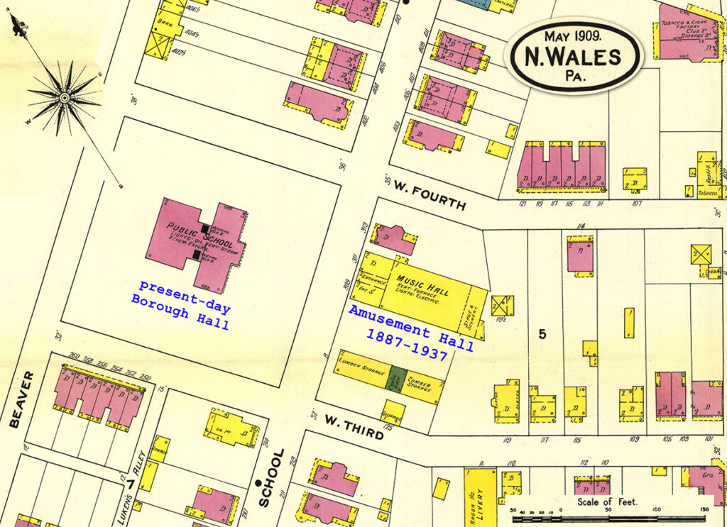
Amusement Hall occupies the center of this excerpt of a 1909 Sanborn insurance map. The yellow tint indicates that the building was of wood construction (brick buildings are shown red). The front portion of the building, facing School Street, was remodeled as a twin house in 1937 (309 and 311 School St.)
In its later years, popular films were screened in the hall. However, with the onset of the Great Depression, proceeds no longer covered expenses. In 1937 most of the hall was torn down, with the front portion remodeled into a twin house which still stands at 309 and 311 School Street.
1920 Election Returns at North Wales Amusement Hall
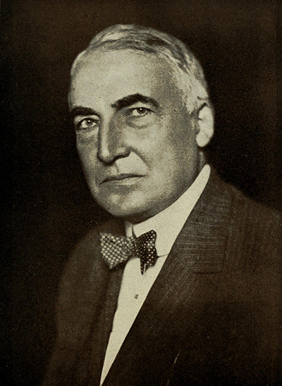
“Next Tuesday evening as the [1920 presidential] election returns are received over Western Union Service, they will be flashed on the screen at Amusement Hall, where a private wire will have been erected and a trained operator will be on hand to receive the news.
“To defray the expenses of having the wire run into the hall, a moving picture show has also been arranged for, the pictures to commence at eight o’clock, and a small admission fee will be charged. A committee consisting of two Republicans and two Democrats will prepare the returns for screen as they are received to assure an impartial presentation of the trend of the election throughout the country.”
Republican Warren G. Harding would win the 1920 presidential election in a landslide.
In 1734, five persons by the name of Jones are mentioned as among the taxables of Gwynedd, including John Jones, son of Robert, so given to distinguish him from John Jones, the penman, and John Jones, the weaver. The others were Cadwalader Jones and Hugh Jones. Possibly the two latter were the other sons of Robert, and inherited the remaining land. A deed of 1760 to George Weidner is witnessed by Roland Evans, Joseph Lukens and H. Vanderslice, before Justice Archibald McLean. The amount paid for the 187 acres was 545 pounds and 17 shillings. How long George Weidner thereafter held the farm we have no means of knowing, but by a subsequent document of 1784, it appears that Jacob Weyant then owned it and at that date sold of a portion comprising twenty-nine acres to William Rex, of Gwynedd. This was taken off the southwestern part.
From the above it will be seen that the original tract of 720 acres, patented to Robert Jones, extended for over two miles in length across Gwynedd, or more than two-thirds of the whole township from Montgomery to Whitpain townships. The breadth of this was something over a half mile.
It is somewhat difficult to fix the northeast boundary, but it is supposed to have been near the present road running from Lansdale (Hancock street) to State road (Route 202), and extending nearly to the Whitpain border. Just above this oblong tract was one still longer and much more narrow, lying across Gwynedd, patented to Evans Hugh (sometimes spelled Pugh). All above, to the Towamencin line, was patented to William Jones, while below, as before mentioned, lay the grants owned by various members of the Evans family, Thomas, Cadwalader, Owen, and Robert.
The will of Robert John is interesting. In his will, he bequeaths to his only son, John, 300 acres, “on which I now reside,” out of which he was to pay two pounds, ten shillings yearly to his mother. There was more land than this that John Jones received from his father. This was “all that part of the tract of land lately bought of Cadwalader Foulke. which lieth to the east side of The Great Road, containing 185 acres, with all the improvements thereon,” out of which he was to pay six pounds annually to his sister, Ellen. This daughter also received some real estate being “the remainder of the said land bought of Foulke, being divided therefrom by The Great Road,” amounting to 150 acres, indicating that the land was on the westerly side of it. It was provided that John might acquire said 150 acres by paying his sister 200 pounds for it.
The will also bequeaths to his daughter “a case of drawers and table, both standing in the new house, and also chamber and white ware.” This shows that Robert John, before his death, had built two houses on this land. It would be interesting to know the exact site of these two dwellings of the pioneer. In 1758, John Jones sold 120½ acres to Abraham Lukens, Sr. In 1760, two years later, as already mentioned, Jones sold 186 acres, lying on the opposite side of the Great Road to George Weidner, and thus, the last of the plantation that John Jones received from his father, passed from his hands.
Almost immediately, the same year, 1758, Abraham Lukens, Sr., sold 80 acres of the tract to his son Abraham Lukens, Jr. Fourteen years later, in 1772, the elder Lukens sold 50 acres on the southwest corner to Philip Heist, and in the same year, Abraham Lukens, Jr. sold 70 acres more to Philip Heist. (This is the land occupied now by Merrybrook, including the old colonial stone house now occupied by Chase R. Whitaker, on the Sumneytown pike.)
This furnishes nearly a complete history of the territory upon which modern North Wales now stands. The name “North Wales” is the translation of the Welsh word “Gwyneth” and from which Elias Clark, the general agent of the North Penn Railroad got the name of “Gwynedd.” It is the name of a river in Wales, U.K.
North Wales, the fifth of the county’s boroughs to be incorporated is situated, as was stated before, in the middle of a countryside whose settlement dates back to early Colonial times, but as a community, North Wales came into existence as the result of the building of the North Pennsylvania Railroad [today’s SEPTA Lansdale-Doylestown line]. When the railroad was opened in 1857, the little community included only a dozen houses and a distillery.
Preceding boroughs had been established by acts of the State Legislature. North Wales was the first in the county to be incorporated by the county court.
In 1849, which is about ten years before the railroad came through and twenty years before the incorporation of the borough, research shows that in what is now the borough limits, and its immediate vicinity, there was then only the farm house of Philip Hurst, the oldest in town, and where now stands the Rorer-Seems Building [3rd and Walnut]; the farm house of Jacob Booz, now the residence of George B. Burpee; the Shearer homestead, now an apartment house at Pennsylvania and Shearer streets; the Schwenk Homestead at Main and School, now occupied by the Reformed Church and private residences; the Miller place, the ground upon which now stands the home of Benjamin Miller; a long house near the parking lot of the Montgomery Bank and Trust Company (the foundations of which were unearthed when the bank building was recently remodeled); a tenement on the site of the home of Frank Rea; the Beaver farm house, now the home of Mrs. Harvey Baer; the Schwenk farm, now the Gordon Tract [today’s Parkside Place].
Of those mentioned, the Hurts, Booz, Miller and Beaver Tracts were along The Great North Wales Road, opened on an old Indian trail, and it was along this road that Ross Gordon, the then-owner of the Gordon Tract, commenced building the Spring-house and Sumneytown Turnpike, finishing it in 1849.
As stated above, when the railroad was built across the Sumneytown Pike, it was evident that this would be a fine place to start a new town, and soon after trains began running, in 1856, a hotel was built, then stores and dwellings. (A post office was opened for the hamlet in 1864. Its first name was Gwynedd, but after a few years the name was changed to North Wales.) The train station was first located on the east side of the single-track railroad, between Main and Second streets. The land for the station was donated by squire Algernon Jenkins in 1857. The first station was a one story affair and was used as both a passenger depot and freight house. The first locomotive on the railroad was called The Civilizer. The steam engine was pulled overland, above the tunnel still under construction, on a temporary track so that the railroad north of the tunnel could be completed.
Next month we will resume our story.
Thispost is sourced from a column entitled Early North Wales: Its History and Its People penned by long-time North Wales resident historian Leon T. Lewis. The article appeared in its original form in the March 17, 1959 issue of the North Penn Reporter.